Riders are responsible for knowing their routes. We do our best to mark courses however we have experienced an increase in vandalism and theft of signs. As a result, riders should either download the routes to their GPS devices, use Ride with GPS on their phones or print out a map of the routes. Examples of course markings can be found at the bottom of this page.
NOTE: All roads are open to public traffic. For your safety, it is imperative that you be constantly aware of your surroundings. Therefore, headphones/earbuds are strictly forbidden.
Gravel Routes
NEW 112 Mile Gravel Ride (Route Marking Paint Color – Pink)
Sponsored by The Cyclist Lawyer.com

This course offers die-hard gravel riders a challenge while providing support along the way. The course offers incredible views and challenging climbs on some of the most remote sections of South Routt.
E-bikes are NOT permitted.
Elevation Gain: 6,012 Ft
Actual Mileage: 112 Miles
Please be prepared to fix your own flats, repair your own bike, and carry enough fluids and energy to support yourself for the 100-mile ride.
Before registering for the gravel ride keep in mind the following:
- This is an extremely remote area. Always be aware of the distance to the next checkpoint, and be prepared to travel that distance with the supplies you carry.
- Snow (yes, even in August), hail, and dramatic temperature shifts are possible on this route.
BE PREPARED - The minimum tire size recommended is 40+ mm. Carrying a pump and tire repair kit is mandatory.
- Participants are responsible for their personal well-being and will have to make their own informed decisions. If you do not feel you are prepared to meet such a challenge, please consider an alternative route.
50-Mile Gravel Ride (Route Marking Paint Color – White)
Sponsored by The Holiday Inn & Suites – Steamboat Springs. Click here for special TDS room rates.
The 50-mile gravel ride is the perfect entry-level gravel ride for most abilities and features a challenging yet rewarding terrain, truly a solid mix of pavement, gravel, and trails this route showcases a bit of it all! E-bikes permitted.
Recommended tire size: 34-40mm with moderate tread
Elevation gain: 2,422ft
Actual Mileage: 49.8 miles
Road Routes
66-mile Yampa Loop (Route Marking Paint Color – Red)

This route takes the rider through several beautiful ranching towns and will explore the base of the Flat Tops mountain range. Riders will go through Stagecoach before diverting south to Phippsburg. The route connects with the paved back roads along the base of the Flat Tops to Yampa, the “Gateway to the Flat Tops.” Riders return to Steamboat via Oak Creek and the Oak Creek Canyon before following the scenic River Road to the Finish.
E-bikes permitted.
Elevation Gain: 3,310 ft.
Actual Mileage: 66 miles
46-mile Oak Creek Loop (Route Marking Paint Color – Blue)
Sponsored by Mountain Valley Bank of Steamboat Springs

The 46-mile ride takes riders south over Yellow Jacket Pass to Stagecoach Reservoir. Riders will continue west and turn north to Oak Creek and then on down the canyon to River Road and return the back way to Steamboat.
E-bikes permitted.
Elevation Gain: 2,123 ft.
25-Mile Family Fun Ride (Route Marking Paint Color – Green)

This route takes riders just south of Steamboat on CO131.
E-bikes permitted.
Elevation Gain: 1021 ft.
HOW TO Download route instructions:
In order to access your route files for your GPS device, either click on the Orange Route title or just below, on the black text labeled, “SEND TO YOUR DEVICE”. From there, follow the instructions on the site.
How do I Print the Map and Cue sheet?
Click on the map to take you to Ride With GPS (RWGPS)
In the upper right hand corner of the map there are two white boxes, on the right box, select the Map view you prefer, we recommend “hybrid” or “Map”
On the left side, Click on the “MORE” button
Select “Print Cue sheet” or Print “Cue Sheet with Map PDF”
Use the pictures below to identify you are on the correct route.
Red = 66 Mile Loop
White = 50 Mile Gravel Course
Pink = 112 Mile Gravel Course


In addition, there will be signs for directions. These are mostly for the 50 and 100-mile Gravel routes.
IMPORTANT NOTE TO 50 And 112 Mile Gravel riders, On County Road 14B and 14E, and on RIVER Road and County Road 35, there will be “IN” and “OUT” signs, please be familiar with these locations. “OUT” directs riders at the beginning of the routes and “IN” directs riders back to the finish at the end of the route.


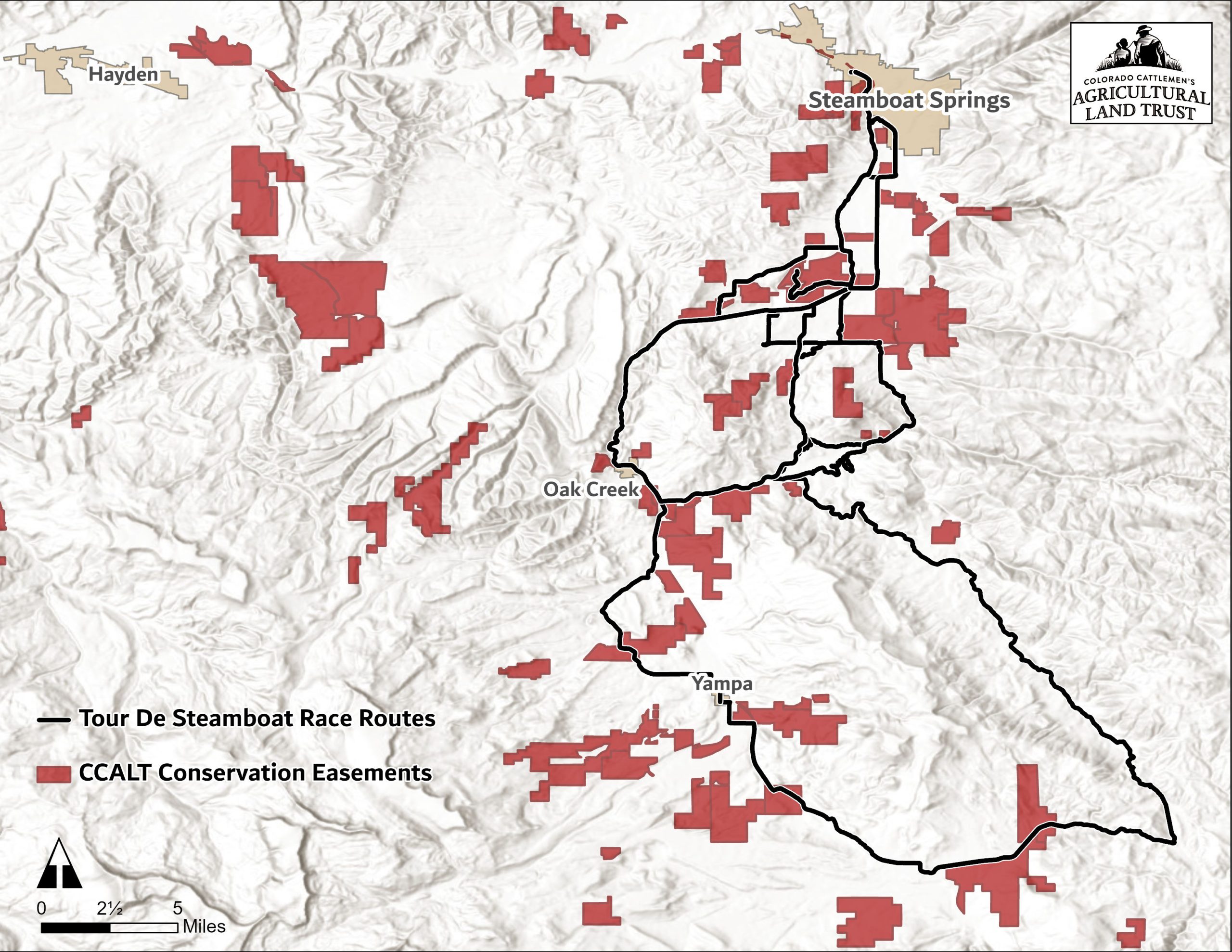
Colorado Cattlemen’s Agricultural Land Trust
When you ride the routes in Steamboat Springs and the Routt County area, you ride by more than just beautiful scenery. You are riding by hundreds of acres of conserved ranches and open space. Check out the map below to see what conserved lands you will be riding by on your ride.